Saturday, December 15, 2012

2012- 2013 Winter

The Midwest was previously predicted to have below-normal snowfall, but according to AccuWeather, we should see an average accumulation.

Previously, El Nino was expected to be in effect, but instead it is in a neutral stage which could cause a few things to happen. Either the northern or southern jet streams could be dominant, or they could merge together. Northern jet stream would allow for cooler air accross the US, while the southern stream would be warmer.

On the East coast, above normal snowfall is predicted because of the expectancy of the two jet streams meeting and creating large storms in the area.

As for the Midwest, the air will be cold and there will be 'clipper' snow storms, which are fast moving weak snow storms. A high frequency of these storms will allow for an average accumulation of snow.


source:
http://www.accuweather.com/en/weather-news/sandy-winter-2012-2013-forecast/1741302

Friday, December 14, 2012

"global warming isn't happening"

To those who have ever uttered those words..

seriously.

Are you aware of anything that is going on in the world? Do you watch the news? Do you hear anything that anyone says about anything ever?

Didn't think so.


Fact of the matter is: it's happening. Change is happening. And it is too late to do anything to stop it.

Arctic ice concentration, Sept 16, 2012, in comparison to previous
record low (yellow line) and historic median extent (black line). 
This year marked yet another record: summer ice loss in the Arctic. Greenland's ice sheet has melted more than it has before, without temperatures even being unusually high when considering the past ten years.

In related studies, the earth's permafrost is beginning to thaw.
Permafrost is ground that stays frozen for two or more years.

The thawing of permafrost is exposing a forest  and other organic matter that has been frozen for hundreds of years. The thawing of this matter allowing the forest to come back to life, but along with it, it's releasing carbon dioxide and methane gas.

"Research shows that the Earth's permafrost contains 1,700 gigatons of carbon 
as frozen organic matter. That's twice the carbon currently in the atmosphere."
from TWC

The release of these gases will be a huge game changer in the realm of global warming. It's another things we need to keep and eye on to ensure change doesn't happen quicker than we, or our infrastructure, can handle...


sources:
http://www.weather.com/news/arctic-breaks-records-report-card-20121206
http://www.weather.com/news/climate-change-melting-permafrost-20121128

Saturday, December 8, 2012

Midwest, lets let the white stuff stay awhile!

An arctic cold front is sweeping down from Canada through the jet stream over the weekend, bringing plenty of chilly winter air. Highs for the Midwest and Plains states probably won't be getting much higher than 20 degrees. This seems cold, but usually around this time, we're having temperatures in the negatives!

As for snow, we should be getting our first inch or so to stick after Sunday, potentially up to four inches, though! Weather.com says that we have our first snow sticking around November 18th.. only about a month late.

A low pressure cell will be moving along with the snow storm, and will cause it to move north on Sunday evening.

Colorado will also be seeing from snow thanks to the jet stream dip, up to 6 inches


A video explaining the weather can be found here:
http://www.weather.com/news/weather-winter/cold-snow-return-20121204


Unfortunately, this 2012 will hold the record for the warmest year for the continental united states. Data has been being kept for the last 118 years. The previous record was 1998.

The only way avoid setting the new record would be if December ended up being about one degree colder than the coldest December recorded. From the looks of things, this is highly unlikely.

Needless to say, this has also been an extremely dry year. At the end of November, approximately 62% of the US was experiencing drought.

With below average rainfall, and above average temperatures, I just hope we can have a white New Year.


sources:
http://www.weather.com/news/weather-winter/cold-snow-return-20121204
http://www.weather.com/news/warmest-year-on-record-noaa-november-20121206

Friday, December 7, 2012

For The Record..

It's snowing!

And this is what I like to see.. especially that 100% !!


Let It Snow, Let It Snow... Please

It is 5:21AM, December 7th and Eau Claire, Wisconsin, the 13th coldest city in the United States, still fails to have snow. There was one morning, quite foggy in my memory, a few weeks ago that snow stuck to the ground for a few hours, but was gone as the sun rose to high noon.

This area usually has around 11 inches of snow on the ground by December first. As a lover of winter and all things snow, this is killing me. I have a snowboard that is begging to hit the mountain and there is nothing I can do about it. My home hill, Granite Peak in Wausau, WI still fails to be open consecutive days. Not to mention its tentative opening day was November 17th. HA!

Across the Midwest, records are being broken for most consecutive days without measurable snowfall. Des Moines, Iowa and Omaha, Nebraska have already broken their records of 277 and 295 days. Chicago and Milwaukee are just days away from setting new records.

The National Weather Service has blamed this on the drought. Damn thing. However, there may be hope.. dim dim hope. The NWS has created a winter storm watch for the Cities and westcentral Wisconsin starting Saturday night and through Sunday evening.


some facts from weather.com:
  • 277 days without measurable snow
  • Record is 280 days set in 1994
  • Average snow total by December 5 is 2.4 inches.
  • 277 days without measurable snow
  • Previous record set in 1889 of 277 days was tied on Thursday.
  • Average snow total by December 5 is 4.3 inches.
  • 276 days with no measurable snow
  • Current record is 279 days set in 1999
  • Average snow total by December 5 is 4.1 inches
  • 286 days with no measurable snow
  • Previous record streak of 285 days set in 2001 was broken on Thursday.
  • Average snow total by December 5 is 3.7 inches


sources:
http://www.weather.com/news/weather-winter/snowless-streaks-midwest-20121205
http://www.miamiherald.com/2012/12/07/3131065/snow-savvy-midwest-cities-breaking.html
http://alerts.weather.gov/cap/wwacapget.php?x=WI124CD566D968.WinterStormWatch.124CD5681698WI.MPXWSWMPX.9041764308ecf182dc881c70d4f58129

Earthquake in Japan

Around 8:18 UTC today (Friday evening in Japan), a 7.3 magnitude earthquake struck 176 miles east off the coast of Sendai, Japan. Or about 200 miles east of Fukushima, Japan.

This earthquake affected the same areas that are still recovering from the destruction of the March 2011 earthquake and tsunami.

CNN reported that nearly all channels stopped their broadcast to alert the area that a quake was going to strike soon. A tsunami warning was also in effect and the announcer also urged the people to get to higher grounds soon. This prompt alert goes to show how shaken up the area is from the 2011 event.

Though the timely alert was a good idea considering the area's still fragile state, a "tsunami" of approximately 1 meter came to shore. The quake lasted about 90 seconds, and left buildings  in Tokyo shaking for quite awhile.


This video shows the building shaking, and also gives some information from reporters:


sources:
http://www.cbsnews.com/8301-202_162-57557719/japan-earthquake-brings-small-tsunami-to-northeastern-disaster-zone/
http://www.cnn.com/2012/12/07/world/asia/japan-earthquake/?hpt=hp_t1

Monday, November 26, 2012

Life After Sandy

New York is working hard to create jobs for those who have been out of work since the aftermath of Hurricane/ Tropical Storm Sandy.

New York Governor Andrew Cuomo and Peter Rivera of the NY Department of Labor are creating government paid jobs to help with the clean up and rebuilding of neighborhoods destroyed by Sandy. Damages from the storm are estimated to be in the tens of billions.

The process is slow, but the resilience of the population is great. Neighbors are helping neighbors to get their lives back in order.


watch the video here:
http://www.weather.com/weather/videos/news-41/top-stories-169/life-after-sandy-jobs-returning-32359

Monday, November 5, 2012

North East Battles Again

A Nor'easter is heading for the north east, just a week after Hurricane Sandy. Some areas are being evacuated to keep residents safe and out of the cold.

http://www.accuweather.com/en/weather-news/noreaster-to-cause-flooding-da/1138252

Saturday, November 3, 2012

Hurricane Sandy (part 4)

Hurricane Sandy (part 3)

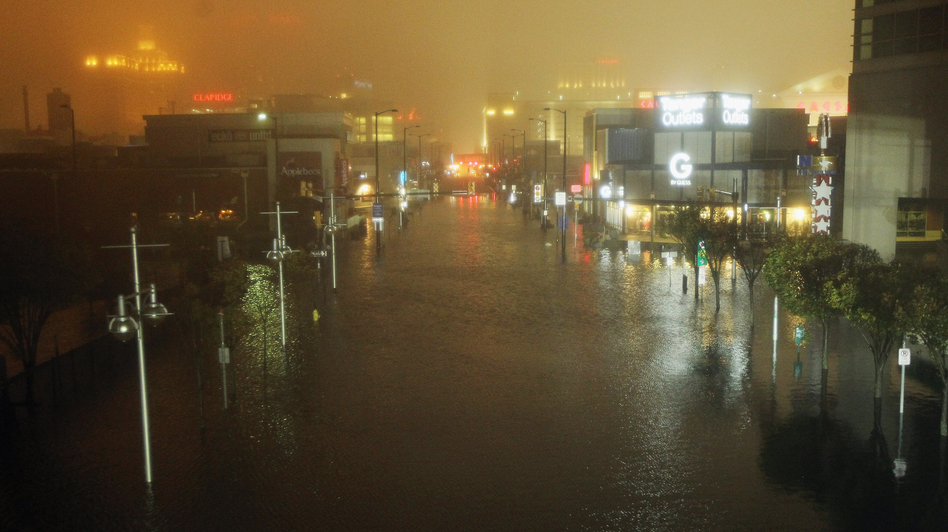
IMMEDIATE DAMAGE ASSESSMENTS

As Superstorm Sandy began to diminish across the north east US, weather.com reported a 'top 5' things that were developing from the storm as of Wednesday afternoon (10-31).

1. Millions without power.
- over 5.9 million were still without power. A total of 8 million reported power loss, even northern Ohio was affected.

2. Numerous fatalities
- falling trees was the main cause of the 47 reported deaths within the US. 69 in the Caribbean, where the storm originated, were also reported.

3. Damages
- at least $10 billion in damages is expected, and up to $50 billion when considering lost business time. Though this number is huge, it did not top Hurricane Katrina.

4. Chilly weather
- the low cold air trough continued to move east and into the affected area, making temperatures in the 30s and 40s. These areas are still without power.

5. Snow!
- 3 feet of snow fell near Richwood, West Virginia, Tennessee and Maryland also saw large amounts.

A link to a ton of pictures showing the destruction of Sandy:
http://www.weather.com/news/weather-hurricanes/hurricane-sandy-pictures-photos2-20121025


NYTimes created a breakdown of damages as well.

Subways:
- All seven of the main subway tunnels under the East River were flooded in the storm, but three would be up and working within the next few days. This is a major transportation system for the metro area, so it will definitely pose a problem for those who will be trying to get to work in the following weeks.

- After the city removes the water from the tunnels, officials need to inspect, clean, and repair ALL of the electrical units that allow the subway system to run efficiently. Saltwater deposits are corrosive to these elements, especially the electric third rail that conducts energy to the trains. A second major element that needs to be inspected are the signal systems that detect where trains are to prevent collisions.

- Lower Manhattan took the hardest hit in terms of flooding for NYC. The 14 foot storm surge topped out subway entrances. October 30th will mark the beginning of work on the subways.


Wastewater:
- 5 out of 14 of NY's wastewater treatment plants are located in the low lying parts of the city. These five also are included in the mandatory evacuation zones before the storm hit. When these plants get filled past capacity, stormwater and sewage mix and then flood the streets and buildings.

- All 14 of the plants ended up being located in a evacuation zone.

> Follow the NYTimes source link for the complete breakdown, along with some great visuals for the damages.


sources:
weather.com breakdown:
http://www.weather.com/news/weather-hurricanes/sandy-top-five-20121028
NYTimes breakdown:
http://www.nytimes.com/interactive/2012/10/30/nyregion/hurricane-sandys-aftermath.html

Hurricane Sandy (part 2)

LANDFALL
water rushes into the NY subway system
through an elevator shaft

Hurricane Sandy made landfall October 29, Monday evening over southern New Jersey.

Here is a post for things that continued to happen before Sandy made landfall:
about 80% of Atlantic City, New Jersey was reported 'underwater'
http://www.npr.org/blogs/thetwo-way/2012/10/29/163846307/hurricane-sandy-latest-news-as-the-worst-begins-to-be-felt

Subway systems flooding, lower Manhattan's power shut down in attempts to prevent damage,  and a crane's supports, atop a high rise building in the process of being constructed, failed and is dangling above the street. Obama also urges people to listen to officials and do not delay evacuation.


Things went from bad to worse as Sandy made landfall:
http://www.npr.org/blogs/thetwo-way/2012/10/29/163900473/sandy-makes-landfall-in-new-jersey-with-punishing-winds-driving-rain

A large area of Queens (New York) was up in flames and many homes were destroyed, NYU Hospital's generator failed after power went out, so patients needed to be transported to other facilities.

New York City and Atlantic City are those most affected by the storm. Major flooding in these areas, as well as problems with the power grid are the worst of their problems.

Some sources report up to 3.1 million are without power across the north east. On top of this, about 8,000 flights have been cancelled so far, and public transportation is at a halt from Washington DC up to Massachusetts.


source:
NPR.org

Hurricane Sandy (part 1)

projected paths for Hurricane Sandy
from: Google
POSSIBILITIES AND MITIGATION

When Hurricane Sandy was just beginning to form in the Caribbean, not much attention was put to it. It began as a cluster of thunderstorm cells, which is common for this area and this time of year. When the storm moved north into the Bahamas and developed into a hurricane, the National Hurricane Center in Miami took note and watched the storm grow and continue northward.  With Sandy looming in the distance of the Bahamas,  there were many projections of what could happen in the next few days. Anything from heading out to the Atlantic, to being sucked inward to the North East US. With so many potential paths, it was hard to know what would happen, but preventative measures on the east coast were beginning to take place.


The reason Sandy is creating such a ruckus in the north east is because of a high pressure system forming an unseasonably low "trough" of cold air. This trough is dipping low into central and midwest US. This cold air, coming down from Canada, is moving eastward, towards Sandy. This system is projected to basically suck Sandy, a low pressure system, inward to the northeast,
making a 'hybrid storm', versus allowing the storm to head
Diagram showing the areas the storm surge will
affect the most, in terms of flooding.
out to sea.


A second factor that adds to Sandy's demeanor, is the lunar cycle. The full-moon stage is nearing, thus high tide is also close. This rises sea levels two to three inches, which added to the predicted storm surge levels of four to eight feet, matter in this case. Sandy covers a lot of area, nearly 1,000 miles wide, which builds up a ton of energy, adding to make storm surges more drastic.


Since Sandy is projected to possibly hit a densely populated area, it has been said it could be worse than Hurricane Katrina. Between the storm surges, high winds, heavy rainfall along the coast, and projected snow in West Virginia, this storm is going to affect a serious amount of people.
Satelite view showing Hurricane Sandy and the deep "trough"
dipping into the central and midwest areas of the US.
from: http://www.nhc.noaa.gov


Mayor Bloomberg of New York City and Mayor Christie from New Jersey teamed up when providing a emergency declaration and helpful public information for the area. The messages given out were clear and consistent, which probably helped to save many lives in the pre-landfall preparatory acts of local governments. Mayor Bloomberg shut down mass transit with a pillow before the storm hit to help urge people to evacuate the area before it was too late. This also allowed the safety of stored transit vehicles for the duration of the storm.


Projected rainfall


sources:
http://www.courant.com/news/opinion/hc-op-fox-hurricane-sandy-unheard-of-weather-happe-20121102,0,3180962.story
http://blog.timesunion.com/weather/sandy-takes-aim-on-northeast-u-s/2515/
USA Today
Accuweather
http://www.climatecentral.org/blogs/hurricane-sandy-poses-growing-threat-to-east-coast-15151?gclid=CMP_ovOlsrMCFcKPPAodzV4Aaw
http://www.mitigationjournal.org/2012/10/hurricane-sandy-setup-for-success.html
http://www.cbsnews.com/8301-201_162-57541836/hurricane-sandy-experts-see-record-destruction-potential-in-storm-surges/

Monday, October 15, 2012

Tropical Storm Rafael

Projected path of Tropical Storm Rafael
source: The Weather Channel
Tropical Storm Rafael is currently sustaining winds of 60 mph. The storm is located about 185 miles north east of San Juan, Puerto Rico, and is projected to hit Bermuda later this week.


Though the storm is not directly affecting the Bahamas and surrounding islands, it is creating intense surf conditions and rip currents on the eastern side beaches reports the National Hurricane Center. Four to six inches of rain are also projected to fall over the Lesser Antilles and Virgin Islands, possibly causing flash floods and mud slides.


The National Hurricane Center is using the technology paradigm in order to project the path of the tropical storm and where it will indirectly cause damage.


sources:
http://www.cnn.com/2012/10/14/world/americas/tropical-storm-rafael/index.html?hpt=wo_c2
http://www.weather.com/news/weather-hurricanes/depression-storm-seventeen-20121011

Tuesday, October 9, 2012

Northeast Indonesia Volcano

Proximate location of Mount Lokon
Mount Lokon, in the North Sulawesi province of Indonesia (which is part of the "Ring of Fire") began to erupt lava and ash around 2:05pm Eastern time on Sunday, October 8th. Nearby residents, up to 3.8 miles away, reported hearing thumping noises around the time of eruption.

The volcano has been active since Friday, 10/5, but only spewing out ash. Officials did issue an early warning, but the mountain was still considered idle until the major eruption.

Eruptions continued after the initial; however, they are unable to be seen because of the thck clouds of ash surrounding the summit of the mountain.

Officials advise residents to limit outdoor activities and stay away from the volcano, but are not issuing an evacuation. This is because of an eruption that happened in July 2011. Mount Lokon had a series of eruptions that prompted officials to evacuate 4,000+ local residents.
They are using the development paradigm in the current situation. Adaption and predictions to make this judgement call. Since the evacuation in 2011 was unnecessary post hoc, they are seeing this as a similar instance and issuing a warning versus going any further.


Source:
http://www.cnn.com/2012/10/07/world/asia/indonesia-volcano/index.html?hpt=wo_bn4

Tuesday, September 25, 2012

Earthquake Near Baja Peninsula

An earthquake shook the ground 47miles north of La Paz, Mexico, on Mexico's Baja Peninsula. No injuries were reported, for the area has a small population. It was noted that quakes rarely happen in the area, despite it being near the Pacific Plate and Caribbean Plate boundary.

Location of La Paz, Mexico. On Baja Peninsula
photo credit: Google maps

Reportedly, the earthquake was ranked 6.2-magnitude (out of 10+) on the Richter scale. It was 6 miles (10km) deep, which makes it a shallow earthquake. Shallow earthquakes are stronger than deep earthquakes because they happen closer to the earth's crust. The crust is much cooler in comparison to the mantle (next layer into the earth). So, when tension builds and builds and builds, it snaps, like an icicle, versus a less violent break, like splitting a warm brownie.

Location of Baja Peninsula, along Pacific and Caribbean Plate boundary
photo credit:  http://www.learner.org/interactives/dynamicearth/images/new_map.jpg


source: 
http://www.cnn.com/2012/09/25/world/americas/mexico-earthquake/index.html

Wednesday, September 19, 2012

Typhoon Sanda, Followup

High waves caused by Typhoon Sanba crash onto a Yeosu beach,
south of Seoul, South Korea, on Monday Sept. 17, 2012
credit: Washington Post
In a follow up to my first post reporting about Typhoon Sanba, the storm did indeed reach South Korea Monday afternoon.

Prior to reaching South Korea, Sanba hit Japan on Sunday. Southwestern Japan homes lost power and some areas experienced flooding. One man, from an island off the southern side of Japan, drowned while swimming  in the high waves caused by the storm.

South Korea received the worst of the storm, with heavy rain, wind, and massive waves crashing along the southern coast. Homes and shops were without power for the day. The storm also caused flight and ferry cancellations. Only one casualty and one injury were reported in South Korea, both via landslides. Over 170 people were left homeless from the storm.

North Korea was not directly hit by the storm, however the outer rings did bring heavy rain into the southern part of the country. Strong winds were also reported near the capital city, Pyongyang.

Path of Typhoon Sanba
credit: wunderground.com


sources:
 http://www.wunderground.com/hurricane/wp201217.asp?MR=1
http://www.washingtonpost.com/world/asia_pacific/after-drenching-japan-and-causing-blackouts-typhoon-sanba-churns-over-south-korea/2012/09/17/fe049d10-0084-11e2-bbf0-e33b4ee2f0e8_story.html

Sunday, September 16, 2012

Typhoon Sanba

credit: Google Maps
On Saturday afternoon, September 15th, the eye of Typhoon Sanba hit the Japanese island of Okinawa. Sanba produced winds up to 79 miles per hour and had an intensity equivalent to a Category 3 hurricane, according to CNN.com. Earlier in the week, Sanba peaked intensity with winds peaking at 175 miles per hour!


credit: wunderground.com
Sanba will head for South Korea, and eventually North Korea early Monday morning, US time. Though Sanba's power will be weakening, the storm will continue to be labeled a typhoon through its landfall journey. Parts of western Japan are under warnings for intense winds and heavy rainfall.


The Philippians experienced flooding from Typhoon Samba's turmoil. Philippine capital, Manila, was one area hit by surprise monsoon rains.


credit: weather.com


More photos from Sanba:
http://www.weather.com/news/typhoon-sanba-slideshow-20120915


source:
http://www.weather.com/news/weather-hurricanes/sanba-western-pacific-20120914
http://www.wunderground.com/tropical/tracking/wp201217.html

Thursday, September 13, 2012

Volcano eruption in Guatemala

photo credit:   CNN iReporter Harby David Marroquin
Around 10am on September 13, 2012, the "Volcan de Fuego" (Fire Volcano) began spitting ash into the air. The volcano is located near Antigua, Guatemala.


photo credit:  http://www.macalester.edu/courses/geog261/aberger/andrew_berger_antigua/index.html 
Officials promptly evacuated residents within a 12 mile radius of the volcano via buses and private cars, though some refused to leave in fear of their possessions being stolen   Mobile health care centers were made available to those in need of respiratory treatment, and only one person was hospitalized in critical condition as of 8:41pm EDT. Ash was reported to be reaching up to 25 miles from the source.


Vinicio Sarazua Santillan, a Red Cross spokesman, told CNN that this was the sixth eruption this year. According to the Smithsonian Nations Museum of Natural History, the Fire Volcano is one of the most active in Central America.


source:
http://www.cnn.com/2012/09/13/world/americas/guatemala-volcano-eruption/index.html?hpt=hp_t3

Thursday, September 6, 2012

Bermuda Braces for Hurricane Leslie

Bermuda is preparing quickly as Hurricane Leslie approaches the island. The US East Coast is also recommended to play it safe until the storm clears out.


source: http://www.cnn.com/2012/09/06/world/americas/bermuda-hurricane-leslie/index.html?iref=obinsite